
Route abseits der üblichen Strecken · Mai bis Oktober
Sri-Lanka-Rundreise: 21 Tage – Die große Runde jenseits der Standardroute
Drei Wochen jenseits der Standardroute: die heiligen Städte, der tamilische Norden, Trincomalee, Pasikudah, die Lagune von Batticaloa, der Surf von Arugam Bay, das Hochland und die Festungsküste.Die längste Reise, die wir anbieten: der Norden, die gesamte Ostküste, das Hochland und der Süden in einer Runde. Die Route reiht die alten Hauptstädte aneinander, dazu das Fort und den alten Baobab von Mannar, die Tempel von Jaffna und die ganze Ostküste von Trincomalee bis Arugam Bay, bevor sie landeinwärts nach Ella schwenkt und entlang der südlichen Festungsküste endet. Drei Wochen klingen lang; mit durchgehend zwei Nächten pro Ort fühlen sie sich selten so an. Beste Zeit: Mai bis September, wenn Norden und Osten in Bestform sind.
- 21 Tage
- Abseits der üblichen Routen
- Mai bis Oktober
- 1.553 km
Die Reise auf der Karte
Jeder Übernachtungsstopp und die Straßen dazwischen.
Tage
21
Fahrzeit
31–40 Std. gesamt
Strecke
1.553 km
Saison
Mai bis Oktober
Am besten von Mai bis September, der Ostküstensaison, für die Strecke von Trincomalee nach Arugam Bay; die Abschnitte im Norden, im Hochland und an der Südküste lassen sich in den meisten anderen Monaten bequem bereisen.
Die Route auf einen Blick
- Flughafen → Negombo8,4 km · 0,5–0,5 Std.
- Negombo → Anuradhapura174 km · 3,5–4,5 Std.
- Anuradhapura → Mannar118 km · 2–2,5 Std.
- Mannar → Jaffna118 km · 2–2,5 Std.
- Jaffna → Anuradhapura196 km · 3,5–4,5 Std.
- Anuradhapura → Trincomalee108 km · 1,5–2 Std.
- Trincomalee → Pasikudah109 km · 2–2,5 Std.
- Pasikudah → Batticaloa33 km · 1–1 Std.
- Batticaloa → Arugam Bay113 km · 2,5–3 Std.
- Arugam Bay → Ella135 km · 3–4 Std.
- Ella → Udawalawe142,4 km · 4–5 Std.
- Udawalawe → Unawatuna130,5 km · 3–4 Std.
- Unawatuna → Galle5,4 km · 0–0,5 Std.
- Galle → Flughafen161,8 km · 3–3,5 Std.
Die Reise, Tag für Tag
Negombo
Der Transfer vom Flughafen nach Negombo, einer Fischerstadt in der Nähe, dauert etwa 30 Minuten; der Abend führt zum Fischmarkt.
Bandaranaike Airport → Negombo8,4 km · 0,5–0,5 Std. · A3Rund um Negombo: das gesamte Angebot, Sie wählen aus
Die Einträge in diesem Bereich sind bisher auf Englisch.

Negombo Beach (Lewis Place)
A long sandy beach in Negombo town, 35km north of Colombo, fronted by a strip of hotels and beach bars popular with international package tourists.

Negombo Fish Market (Lellama)
Sri Lanka's busiest wholesale fish auction, held at Lellama harbour from 6am daily, processing hundreds of tonnes of fresh catch.
Aktivitäten
- Negombo Deep-Sea Fishing Charter4h
- Negombo Dutch Canal Cycling Tour2.5h
- Negombo Lagoon and Fish Market Dawn Boat Tour3h
Anuradhapura
Über Chilaw und Puttalam führt die Straße nach Anuradhapura, etwa 3 Stunden 30 Minuten.
Negombo → Anuradhapura174 km · 3,5–4,5 Std. · A3, A12vorbei an Chilaw (Tempelstadt Munneswaram), Puttalam (Lagune mit Salzgärten)Rund um Anuradhapura: das gesamte Angebot, Sie wählen aus
Die Einträge in diesem Bereich sind bisher auf Englisch.

Tissa Wewa
Ancient reservoir built by King Devanampiyatissa in the 3rd century BC, now a wildlife haven where elephants come to drink at dusk.

Isurumuniya Rock Temple
3rd-century BC rock temple in Anuradhapura with a famous carved panel of 'The Lovers', a royal bathing pool, and elephants carved in rock.

Jetavanaramaya Stupa
3rd-century stupa that once stood 122m tall, making it the world's third tallest structure when built by King Mahasena around 275 AD.

Sri Maha Bodhi
The oldest documented tree in the world, planted 288 BC from a cutting of the original Bodhi Tree under which the Buddha attained enlightenment.

Ruwanwelisaya Stupa
2nd-century BC stupa built by King Dutugemunu, standing 103m tall and enshrining relics of the Buddha in Anuradhapura.

Lovamahapaya
Ruins of a 9-storey palace from the 2nd century BC in Anuradhapura, marked today by 1,600 granite columns standing in a 40x40 grid.
Alle 10 Orte anzeigenWeniger anzeigen

Samadhi Buddha Statue
4th-century seated meditation Buddha carved from dolomite marble, widely considered one of the finest ancient sculptures in Sri Lanka.

Abhayagiri Dagoba
1st-century BC stupa in Anuradhapura that once rose to 115m, making it the second tallest stupa ever built in the ancient world.

Mihintale
Sacred mountain where Buddhism was introduced to Sri Lanka in 247 BC by Mahinda, son of Emperor Ashoka, reached by climbing 1,840 granite steps.

Aukana Buddha Statue
5th-century standing Buddha carved from a single granite rock face, standing 12m tall, near Kekirawa between Anuradhapura and Dambulla.
Aktivitäten
- Anuradhapura Sacred City Cycling Tour3h
- Nuwara Wewa Sunset Boat Ride, Anuradhapura1h
Anuradhapura, in Ihrem Tempo
Die heilige Stadt Anuradhapura und Mihintale füllen gemeinsam den Tag; Mihintale ist der Hügel, auf dem der Buddhismus die Insel 247 v. Chr. erreichte.
Mannar
Mannar liegt etwa 2 Stunden 10 Minuten entfernt, über Medawachchiya und Adampan. Das Fort von Mannar, 1560 von den Portugiesen erbaut, und der Baobab-Baum der Insel, auf mehrere Hundert Jahre geschätzt und angeblich als Samen aus Afrika gekommen, füllen den Tag.
Anuradhapura → Mannar118 km · 2–2,5 Std. · A14Rund um Mannar: das gesamte Angebot, Sie wählen aus
Die Einträge in diesem Bereich sind bisher auf Englisch.

Mannar Fort
A Portuguese-built coastal fortification from 1560 on Mannar Island, later expanded by the Dutch — one of the oldest European forts in Sri Lanka and en route to the north by road.

Mannar Baobab Tree
A baobab tree on Mannar Island estimated at over 700 years old with a trunk circumference of 19.5m — one of the largest and oldest baobab trees in Asia, brought by Arab traders.
Aktivitäten
- Mannar Birdwatching and Baobab Tree Tour3h
Jaffna
Die Straße nach Jaffna über Vellankulam und Chavakachcheri dauert etwa 2 Stunden; der Abend gehört dem Fort von Jaffna, einer sternförmigen holländischen Festung auf portugiesischen Fundamenten.
Mannar → Jaffna118 km · 2–2,5 Std. · A32Rund um Jaffna: das gesamte Angebot, Sie wählen aus
Die Einträge in diesem Bereich sind bisher auf Englisch.

Jaffna Public Library
Sri Lanka's largest regional library, rebuilt after its deliberate burning in 1981 — the destruction of 97,000 Tamil manuscripts and books was one of the most traumatic cultural attacks of the civil war.
- JM
Jaffna Market
The main covered market of Jaffna town, selling fresh produce unique to the north: palmyra toddy, dried fish, chilies, and traditional Tamil condiments rarely found elsewhere in Sri Lanka.

Jaffna Fort
A Dutch-built star fort from 1658 on Jaffna's coast — one of the best-preserved colonial fortifications in Asia, with 4km of intact ramparts and a dry moat.
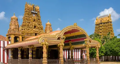
Nallur Kandaswamy Kovil
The most important Hindu temple in northern Sri Lanka, dedicated to Lord Murugan — the 25-day Nallur Festival each August draws hundreds of thousands of Tamil Hindu devotees.

Dambakola Patuna
The historically significant landing site on Sri Lanka's northern coast where the Bodhi sapling and the Sanghamitta Theri arrived from India in 288 BC, marking the beginning of Sri Lanka's Buddhist tradition.

Nainativu Island
A small island in Jaffna Lagoon holding both a major Buddhist temple and a major Hindu temple on the same 1.5km strip of land, making it unique in Sri Lanka.
Alle 9 Orte anzeigenWeniger anzeigen
- CB
Casuarina Beach
A shallow, calm beach near Karainagar on the Jaffna peninsula, named for its casuarina tree shade line — one of the few genuinely swimmable beaches in the north of Sri Lanka.

Keerimalai Hot Springs
Natural freshwater springs that emerge at the ocean's edge near Jaffna, historically used for bathing by pilgrims on the Nainativu route — the water is mineral-rich and believed curative.
- PP
Point Pedro
The northernmost point of Sri Lanka, a coastal town where the Indian Ocean meets the Bay of Bengal — a geographic landmark 330km from Dondra Head, the island's southernmost point.
Aktivitäten
- Delft Island Day Tour (Wild Horses and Baobab)5h
- Jaffna Heritage Walking Tour (Fort, Library, Market)2.5h
- Jaffna Town Cycling Tour2h
- Nagadeepa / Nainativu Island Temple Boat Trip2h
Jaffna, in Ihrem Tempo
Der Tag in Jaffna umfasst den Nallur Kandaswamy Kovil, Jaffnas wichtigsten Hindu-Tempel für Murugan, den Markt und einen Ausflug zur Insel Delft oder nach Nainativu, einer hinduistischen und buddhistischen Pilgerinsel.
Anuradhapura
Die Rückfahrt nach Anuradhapura läuft über die A9 durch Elephant Pass, Kilinochchi und Vavuniya, etwa 3 Stunden 30 Minuten.
Jaffna → Anuradhapura196 km · 3,5–4,5 Std. · A9Trincomalee
Trincomalee liegt etwa 1 Stunde 45 Minuten entfernt, über die A12 durch Kebithigollewa und Kantale.
Anuradhapura → Trincomalee108 km · 1,5–2 Std. · A12Rund um Trincomalee: das gesamte Angebot, Sie wählen aus
Die Einträge in diesem Bereich sind bisher auf Englisch.

Trincomalee Harbour
One of the world's largest natural deep-water harbours, cited by Lord Nelson as the finest in the Indian Ocean, spanning 15 km across.

Koneswaram Temple
Ancient Hindu cliff temple dedicated to Shiva, perched 130 m above the sea at Swami Rock, Trincomalee.

Fort Frederick
17th-century colonial fort on Swami Rock, Trincomalee, built by Portuguese in 1624, rebuilt by Dutch, and garrisoned by British until independence.
- UB
Uppuveli Beach
Quiet 3-kilometre beach 4 km north of Trincomalee town with calm May-September surf, budget guesthouses, and a WWII Commonwealth war cemetery.

Swami Rock and Lover's Leap
130-metre sea cliff at the tip of Swami Rock, Trincomalee, with a documented Dutch-era legend and unobstructed views over the Indian Ocean.

Marble Beach
Secluded 400-metre military-reservation beach 5 km north of Trincomalee, considered by many visitors to have the clearest water on the east coast.
Alle 8 Orte anzeigenWeniger anzeigen
Aktivitäten
- Kanniya Hot Springs Visit0.75h
- Pigeon Island Snorkeling Boat Trip3h
- Trincomalee Whale Watching Boat Tour4h
Zum Weiterlesen vor der Reise
Trincomalee, in Ihrem Tempo
Der Tag in Trincomalee umfasst den Koneswaram-Tempel, einen Shiva-Tempel auf der Landzunge Swami Rock, und eine Bootstour nach Pigeon Island, dessen flache Riffe gut sind, um Schwarzspitzen-Riffhaie zu sehen.
Pasikudah
Über Kalkudah und Valachchenai nach Pasikudah, etwa 2 Stunden, mit dem Nachmittag am Strand.
Trincomalee → Pasikudah109 km · 2–2,5 Std. · A15Rund um Pasikudah: das gesamte Angebot, Sie wählen aus
Die Einträge in diesem Bereich sind bisher auf Englisch.
Aktivitäten
- Pasikuda Glass-Bottom Boat and Shallow Reef Snorkel1.5h
Pasikudah, in Ihrem Tempo
Ein freier Tag in Pasikudah.
Batticaloa
Batticaloa liegt etwa 45 Minuten entfernt, mit einer Nachmittagsbootstour auf der Lagune.
Pasikudah → Batticaloa33 km · 1–1 Std. · A15Rund um Batticaloa: das gesamte Angebot, Sie wählen aus
Die Einträge in diesem Bereich sind bisher auf Englisch.
Aktivitäten
- Batticaloa Lagoon Guided Boat Tour1.5h
Arugam Bay
Arugam Bay liegt etwa 2 Stunden 35 Minuten entfernt, über Kalmunai, Akkaraipattu und Pottuvil.
Batticaloa → Arugam Bay113 km · 2,5–3 Std. · A4Rund um Arugam Bay: das gesamte Angebot, Sie wählen aus
Die Einträge in diesem Bereich sind bisher auf Englisch.

Arugam Bay Beach
Sri Lanka's premier surf break, ranked among the world's top 10 point breaks, with a right-hander that works best May to October.

Arugam Bay Pottuvil Lagoon
Mangrove-lined tidal lagoon 2 km from Arugam Bay with resident mugger crocodiles, painted storks, and canoe tours through narrow channels.
- KF
Kudumbigala Forest Hermitage
Active forest monastery of cave-dwelling monks near Panama, Ampara, with ancient rock inscriptions, a 2nd-century BCE origin, and dramatic boulder landscape.
Aktivitäten
- Arugam Bay Beginner Surf Lesson2h
- Kumana National Park Jeep Safari4h
- Pottuvil Lagoon Mangrove Safari (Crocodile Spotting)2h
Zum Weiterlesen vor der Reise
Arugam Bay, in Ihrem Tempo
Eine Surfstunde am Main Point oder ein Tagesausflug in den Kumana-Nationalpark, bekannt für seine dichte Vogelwelt.
Ella
Die Straße nach Ella, einem kleinen Ort im Teehochland, läuft über Siyambalanduwa, Monaragala und Wellawaya, etwa 3 Stunden 10 Minuten.
Arugam Bay → Ella135 km · 3–4 Std. · A4, A23vorbei an Wellawaya (wo das Bergland in die Ebene übergeht)Rund um Ella: das gesamte Angebot, Sie wählen aus
Die Einträge in diesem Bereich sind bisher auf Englisch.

Little Adam's Peak
An easy 45-minute hike from Ella town to a 1,141m summit with 360-degree views — the most accessible hilltop panorama in the Ella region.

Ella Gap Viewpoint
A natural break in the hill country escarpment above Ella town with a sweeping view down a 1,000m drop to the southern coastal plains on clear days.

Ravana Falls
A 25m fan-shaped waterfall on the Badulla–Ella road, one of Sri Lanka's widest falls, associated with the Ramayana legend of King Ravana.

Nine Arch Bridge
A 91m colonial viaduct built in 1921 with nine arches, best photographed when a train crosses — departures from Ella at approximately 9:10am and 3:15pm daily.

Rawana Ella Cave
A natural cave in the hillside near Ella said by local tradition to be where King Ravana hid Sita during the Ramayana epic, located close to Ravana Falls.

Ella Rock
A 1,041m summit above Ella town reached by a 3-hour round-trip hike through tea estates and jungle, with panoramic views across the Ella Gap valley.
Alle 9 Orte anzeigenWeniger anzeigen

Demodara Railway Loop
A unique engineering feature of the hill country railway where the track loops under itself in a 360-degree spiral — the train passes over the same point at two different levels.
- BW
Bogoda Wooden Bridge
A 16th-century wooden bridge over Hali Ela Oya near Hali-Ela, one of the oldest surviving wooden structures in Sri Lanka, with an unusual roof built to protect the timbers.

Dunhinda Falls
A 64m waterfall 5km from Badulla, among the widest falls in Sri Lanka, reached by a 30-minute forest trail along the Uma Oya river.
Aktivitäten
- Ella Home-Hosted Cooking Class3h
- Ella Tea Factory Tour and Tasting (Halpewatte)1.5h
- Flying Ravana Zipline, Ella1h
- Kandy to Ella Scenic Train Journey (Reserved Seat)6.5h
- Nanu Oya to Ella Scenic Train Journey (Reserved Seat)3h
Zum Weiterlesen vor der Reise
Ella, in Ihrem Tempo
Der Tag in Ella umfasst die Nine Arch Bridge, ein Eisenbahnviadukt aus der Kolonialzeit, das wegen Stahlmangels im Krieg ohne Stahl gebaut wurde, den Little Adam's Peak und den Ella Rock, beides Gratwege mit Blick über die Teeterrassen.
Udawalawe
Udawalawe liegt etwa 4 Stunden entfernt, über Haputale, Beragala und Wellawaya, mit einer Elefantensafari am Nachmittag.
Ella → Udawalawe142,4 km · 4–5 Std. · A16, A23, A2vorbei an Haputale, Wellawaya (wo das Bergland in die Ebene übergeht)Rund um Udawalawe: das gesamte Angebot, Sie wählen aus
Die Einträge in diesem Bereich sind bisher auf Englisch.
Aktivitäten
- Elephant Transit Home Feeding Viewing1h
- Sinharaja Forest Reserve Guided Rainforest Trek4h
- Udawalawe National Park Jeep Safari3h
Zum Weiterlesen vor der Reise
Unawatuna
Über Mirissa und Weligama geht es nach Unawatuna, einem Strandort vor Galle, etwa 2 Stunden 45 Minuten, mit dem Nachmittag am Strand.
Udawalawe → Unawatuna130,5 km · 3–4 Std. · A18, E01, A2vorbei an Mirissa (Walbeobachtungshafen), Weligama (Surfbucht)Rund um Unawatuna: das gesamte Angebot, Sie wählen aus
Die Einträge in diesem Bereich sind bisher auf Englisch.

Unawatuna Beach
A sheltered crescent bay 3km south of Galle with calm year-round swimming, coral reefs 50m offshore, and the highest concentration of guesthouses on the south coast.

Jungle Beach (Rumassala)
A secluded 150m cove on the forested Rumassala headland, 10 minutes from Unawatuna, with no food vendors, dense jungle to the waterline, and cleaner water than the main bay.
Aktivitäten
- Rumassala Forest Hike to the Japanese Peace Pagoda1.5h
- Unawatuna Reef Snorkeling and Beginner Dive Trip2.5h
Galle
Galle liegt 15 Minuten entfernt; der Nachmittag führt nach Galle Fort, einer im 17. Jahrhundert von den Niederländern erbauten Festung, und auf die Wälle.
Unawatuna → Galle5,4 km · 0–0,5 Std. · A2Rund um Galle: das gesamte Angebot, Sie wählen aus
Die Einträge in diesem Bereich sind bisher auf Englisch.

Galle Fort
A Dutch colonial fort built in 1663, enclosing a 400-year-old town of 400 buildings within 36 hectares on a rocky peninsula in Galle city.

Galle Lighthouse
A working 18m Dutch-era lighthouse inside Galle Fort, first lit in 1848, marking the entrance to Galle Harbour — the oldest lighthouse in Sri Lanka.
Aktivitäten
- Galle Fort Guided Walking Tour2h
- Koggala Lake Boat Safari (Cinnamon Island)1.5h
Galle, in Ihrem Tempo
Ein freier Tag in Galle: die holländisch-reformierte Kirche von 1755, der Leuchtturm und die Festungsmauern bei Sonnenuntergang.
Rückflug
Die Fahrt zum Flughafen führt über Colombo auf den Schnellstraßen E01 und E03, etwa 2 Stunden 45 Minuten, zum Abflug.
Galle → Airport161,8 km · 3–3,5 Std. · E01, E03


Jeden Tag dieser Route fahren Sie mit eigenem Fahrer und Wagen; so funktioniert die Rundreise mit privatem Fahrer. Prüfen Sie die Einreisebestimmungen und die beste Reisezeit, bevor Sie Termine festlegen.
Machen Sie diese Route zu Ihrer
Diese Route ist ein Ausgangspunkt, kein festes Produkt. Öffnen Sie sie im Reiseplaner und bauen Sie sie selbst um, oder schicken Sie sie unserem Team in Kandy und bekommen Sie eine angepasste Fassung mit Angebot. Gezahlt wird erst, wenn der endgültige Plan steht.
Unser Team antwortet auf Englisch (WhatsApp oder E-Mail).