
Romantische Route · November bis April
Sri-Lanka-Rundreise: 14 Tage – Große Hochzeitsreise
Die Hochzeitsreise ohne Eile: je zwei Nächte in Sigiriya, Nuwara Eliya, Ella, Mirissa und Bentota, in der Mitte die Zugfahrt zwischen Nuwara Eliya und Ella.Vierzehn Tage mit fast keinen Einzelnächten. In Sigiriya, Nuwara Eliya, Ella, Mirissa und Bentota bleiben Sie jeweils zwei Nächte, sodass die Reise atmet statt zu hetzen. Die Zugfahrt durchs Teeland, eine private Safari in Udawalawe und die Walsaison in Mirissa sind die Fixpunkte; den Rest gestalten Sie. Die Reise endet in Bentota, etwa zwei Stunden fünfzehn Minuten vom Flughafen über die Schnellstraße.
- 14 Tage
- Romantisch
- November bis April
- 785 km
Die Reise auf der Karte
Jeder Übernachtungsstopp und die Straßen dazwischen.
Tage
14
Fahrzeit
19–25 Std. gesamt
Strecke
785 km
Saison
November bis April
Die Route auf einen Blick
- Flughafen → Negombo8,4 km · 0,5–0,5 Std.
- Negombo → Sigiriya149,1 km · 3,5–4,5 Std.
- Sigiriya → Kandy91,2 km · 2,5–3 Std.
- Kandy → Nuwara Eliya73,3 km · 2,5–3 Std.
- Nuwara Eliya → Ella56 km · 1,5–2 Std.
- Ella → Udawalawe101,9 km · 2,5–3 Std.
- Udawalawe → Mirissa100 km · 2–2,5 Std.
- Mirissa → Bentota92,3 km · 2,5–4 Std.
- Bentota → Flughafen113 km · 2–3 Std.
Die Reise, Tag für Tag
Negombo
Der Flughafen Bandaranaike liegt nah an der Küste, und der Transfer nach Negombo, einer Fischerstadt an einer Lagune, dauert etwa 30 Minuten. Der Nachmittag gehört dem Strand und dem Fischmarkt, wenn die Auslegerboote hereinkommen.
Bandaranaike Airport → Negombo8,4 km · 0,5–0,5 Std. · A3Rund um Negombo: das gesamte Angebot, Sie wählen aus
Die Einträge in diesem Bereich sind bisher auf Englisch.

Negombo Beach (Lewis Place)
A long sandy beach in Negombo town, 35km north of Colombo, fronted by a strip of hotels and beach bars popular with international package tourists.

Negombo Fish Market (Lellama)
Sri Lanka's busiest wholesale fish auction, held at Lellama harbour from 6am daily, processing hundreds of tonnes of fresh catch.
Aktivitäten
- Negombo Deep-Sea Fishing Charter4h
- Negombo Dutch Canal Cycling Tour2.5h
- Negombo Lagoon and Fish Market Dawn Boat Tour3h
Sigiriya
Die Straße nach Osten führt nach Sigiriya, einer 200 Meter hohen Felsenzitadelle, die steil aus dem Dschungel aufragt und im 5. Jahrhundert als Königspalast entstand (etwa 4 Stunden über Kurunegala und Dambulla). Zwei Nächte.
Negombo → Sigiriya149,1 km · 3,5–4,5 Std. · A6vorbei an Kurunegala (Stadt am Felsen und See), Dambulla (Höhlentempel von Dambulla)Rund um Sigiriya: das gesamte Angebot, Sie wählen aus
Die Einträge in diesem Bereich sind bisher auf Englisch.

Sigiriya Frescoes & Mirror Wall
Ancient 5th-century frescoes depicting 21 cloud maidens painted on Sigiriya Rock, alongside a polished mirror wall with 8th-century visitor inscriptions.

Sigiriya Rock Fortress
5th-century palace and fortress built atop a 200m granite monolith by King Kashyapa, a UNESCO World Heritage Site and the most visited paid attraction in Sri Lanka.

Ayurveda & Wellness Sessions
Traditional Ayurvedic treatments including herbal oil massages and steam baths offered at resorts and village centres in the Sigiriya area.

Sigiriya Nature Walks
Guided village and jungle walks through the lowland scrub forest and paddy fields around Sigiriya village, covering local farming, birding, and rural life.
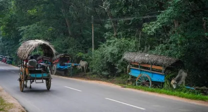
Sigiriya Village Tour
A half-day guided village experience in Sigiriya showing traditional bullock cart rides, catamarans on a village tank, cooking demonstrations, and paddy farming.

Pidurangala Rock
A 200m rock outcrop 1.5km north of Sigiriya offering the best panoramic view of Sigiriya Rock, with a reclining Buddha at the summit base dating to the 6th century.
Zum Weiterlesen vor der Reise
Sigiriya, in Ihrem Tempo
Sigiriya bei Sonnenaufgang besteigen, rund 1.200 Stufen an den alten Fresken vorbei, danach der Nachmittag im Höhlentempel von Dambulla, fünf Höhlen mit buddhistischen Wandmalereien und Statuen, in einen Granitfelsen geschlagen.
Kandy
Es folgt Kandy, die Bergstadt des letzten Königreichs Sri Lankas (etwa 3 Stunden durch die Gewürzgärten bei Matale). Es lohnt sich, den Tag um die abendliche Puja mit Trommeln und Flöten im Zahntempel herum zu planen.
Sigiriya → Kandy91,2 km · 2,5–3 Std. · A6, A9vorbei an Dambulla (Höhlentempel von Dambulla), Matale (Gewürzgärten)Rund um Kandy: das gesamte Angebot, Sie wählen aus
Die Einträge in diesem Bereich sind bisher auf Englisch.

Temple of the Tooth Relic
Sri Dalada Maligawa in Kandy houses a tooth relic of the Buddha and has been the most sacred Buddhist site in Sri Lanka since the 4th century AD.

Udawattakele Forest Reserve
A 104-hectare protected cloud forest reserve directly above central Kandy, with 68 recorded bird species and multiple walking trails through bamboo groves and tropical trees.

Kandy Lake
Artificial lake built by King Sri Wickrama Rajasinha in 1807 at the centre of Kandy, encircled by a 3km walkway and flanked by the Temple of the Tooth.

Bahirawakanda Vihara Buddha Statue
A 26.8-metre white seated Buddha statue on Bahirawakanda Hill overlooking central Kandy, visible from most of the city and accessible by a 30-minute walk or tuk-tuk.

Royal Botanical Gardens Peradeniya
Sri Lanka's largest botanical garden covering 147 acres on a meander of the Mahaweli River, established in 1821 with over 4,000 plant species including a 350-year-old Java fig tree.

Hanthana Mountain Range
A ridge of peaks reaching 1,467m immediately south-west of Kandy, offering half-day hiking trails through tea estates with views over the Kandy valley.
Alle 12 Orte anzeigenWeniger anzeigen

Embekke Devale
A 14th-century Hindu-Buddhist devale in Udunuwara near Kandy, renowned for its intricately carved wooden pillars depicting wrestlers, peacocks, and mythological figures.

Lankatilaka Vihara
A 14th-century rock temple in Udunuwara near Kandy built under King Bhuvanekabahu IV, with a 14-metre Buddha shrine carved into a granite outcrop and notable Kandyan frescoes.

Ambuluwawa Tower
A 48-metre spiral tower on a 1,600m peak near Gampola with a multi-religious complex below and 360-degree views reaching Kandy, Hatton, and the coastal plains.
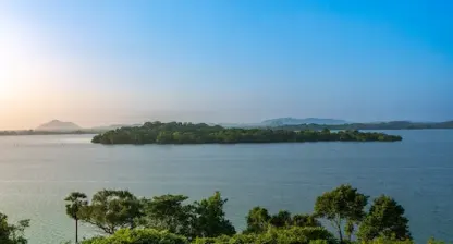
Victoria Dam & Reservoir
Sri Lanka's largest hydropower dam, completed in 1985 on the Mahaweli River with a 122-metre arch dam wall, creating a 722-hectare reservoir visible from a public viewing platform.

Aluviharaya Rock Cave Temple
A 1st-century BC rock cave monastery near Matale where the Tripitaka Buddhist scriptures were first committed to writing on ola palm leaves, with a restored complex of cave shrines.

Knuckles Mountain Range
A UNESCO World Heritage mountain range northeast of Kandy with peaks up to 1,863m, covering 155 sq km of cloud forest with over 34 endemic vertebrate species and 20+ trekking routes.
Aktivitäten
- Ceylon Tea Museum Guided Tour (Hantana)1.5h
- Kandy Esala Perahera Evening Viewing (August festival)3h
- Kandy Home-Hosted Cooking Class3h
- Kandyan Cultural Dance and Drumming Show1h
- Knuckles Range Guided Day Trek6h
Zum Weiterlesen vor der Reise
Nuwara Eliya
Ein Morgen im Königlichen Botanischen Garten Peradeniya, 59 Hektar mit Riesenbambus und Orchideenhäusern, dann der Aufstieg nach Nuwara Eliya, einer früheren britischen Bergstation auf 1.868 Metern zwischen den Teeplantagen (etwa 2 Stunden 45 Minuten durch die Wasserfälle des Ramboda-Passes). Zwei Nächte.
Kandy → Nuwara Eliya73,3 km · 2,5–3 Std. · A5Rund um Nuwara Eliya: das gesamte Angebot, Sie wählen aus
Die Einträge in diesem Bereich sind bisher auf Englisch.

Seetha Amman Kovil
A Hindu temple in Sita Eliya near Nuwara Eliya, built at the site where Ramayana's Sita is believed to have been held captive by King Ravana.

Pink Post Office
A functioning colonial-era post office in central Nuwara Eliya built in 1894, one of the most photographed colonial buildings in Sri Lanka's hill country.

Gregory Lake
Colonial-era reservoir built in 1873 in Nuwara Eliya at 1,868m elevation, offering boating, lakeside cycling, and views of surrounding tea hills.

Lover's Leap Waterfall
A 30-metre waterfall on the Laxapana River in Nuwara Eliya, accessible via a short walk through a tea estate, named after a colonial-era legend.
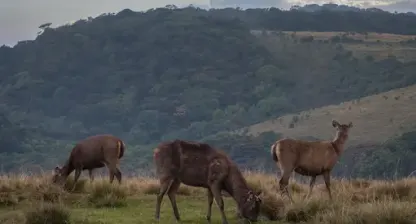
Horton Plains National Park
UNESCO World Heritage plateau at 2,100-2,300m elevation in the Central Highlands, home to World's End cliff dropping 870m and the 20m Baker's Falls.
Aktivitäten
- Gregory Lake Pedal and Speed Boating1h
- Horton Plains World's End Guided Nature Walk3.5h
- Nuwara Eliya Strawberry Farm Visit1h
- Nuwara Eliya Tea Factory Tour and Tasting1.5h
Zum Weiterlesen vor der Reise
Nuwara Eliya, in Ihrem Tempo
Ein ganzer Tag in Nuwara Eliya: eine Führung durch die Pedro-Teeplantage, gegründet 1885 und eine der älteren Plantagen der Gegend, die noch in Betrieb sind, ein Ruderboot auf dem Gregory-See und am Nachmittag der Botanische Garten Hakgala, ein Reservat für kühles Klima mit Rosen und Nebelwald, angelegt 1861.
Ella
In Nanu Oya beginnt die Zugfahrt nach Ella (etwa 3 Stunden), vorbei an den Ausblicken über die Ella Gap, während der Wagen das Gepäck über die Straße bringt und Sie dort trifft. Zwei Nächte.
Nuwara Eliya → Ella56 km · 1,5–2 Std. · A5Rund um Ella: das gesamte Angebot, Sie wählen aus
Die Einträge in diesem Bereich sind bisher auf Englisch.

Little Adam's Peak
An easy 45-minute hike from Ella town to a 1,141m summit with 360-degree views — the most accessible hilltop panorama in the Ella region.

Ella Gap Viewpoint
A natural break in the hill country escarpment above Ella town with a sweeping view down a 1,000m drop to the southern coastal plains on clear days.

Ravana Falls
A 25m fan-shaped waterfall on the Badulla–Ella road, one of Sri Lanka's widest falls, associated with the Ramayana legend of King Ravana.

Nine Arch Bridge
A 91m colonial viaduct built in 1921 with nine arches, best photographed when a train crosses — departures from Ella at approximately 9:10am and 3:15pm daily.

Rawana Ella Cave
A natural cave in the hillside near Ella said by local tradition to be where King Ravana hid Sita during the Ramayana epic, located close to Ravana Falls.

Ella Rock
A 1,041m summit above Ella town reached by a 3-hour round-trip hike through tea estates and jungle, with panoramic views across the Ella Gap valley.
Alle 9 Orte anzeigenWeniger anzeigen

Demodara Railway Loop
A unique engineering feature of the hill country railway where the track loops under itself in a 360-degree spiral — the train passes over the same point at two different levels.
- BW
Bogoda Wooden Bridge
A 16th-century wooden bridge over Hali Ela Oya near Hali-Ela, one of the oldest surviving wooden structures in Sri Lanka, with an unusual roof built to protect the timbers.

Dunhinda Falls
A 64m waterfall 5km from Badulla, among the widest falls in Sri Lanka, reached by a 30-minute forest trail along the Uma Oya river.
Aktivitäten
- Ella Home-Hosted Cooking Class3h
- Ella Tea Factory Tour and Tasting (Halpewatte)1.5h
- Flying Ravana Zipline, Ella1h
- Kandy to Ella Scenic Train Journey (Reserved Seat)6.5h
- Nanu Oya to Ella Scenic Train Journey (Reserved Seat)3h
Zum Weiterlesen vor der Reise
Ella, in Ihrem Tempo
Ella, ein kleiner Bergort an der Bahnstrecke, verdient einen ganzen Tag: die Nine Arch Bridge, ein Eisenbahnviadukt aus der Kolonialzeit, bei Sonnenaufgang, am Nachmittag ein Aufstieg auf den Little Adam's Peak.
Udawalawe
Als Nächstes Udawalawe (etwa 2 Stunden 45 Minuten über Wellawaya), für eine Nachmittagssafari im Jeep; der Udawalawe-Nationalpark hat einige der verlässlichsten wilden Elefantenherden des Landes.
Ella → Udawalawe101,9 km · 2,5–3 Std. · A23, A2vorbei an Wellawaya (wo das Bergland in die Ebene übergeht)Rund um Udawalawe: das gesamte Angebot, Sie wählen aus
Die Einträge in diesem Bereich sind bisher auf Englisch.
Aktivitäten
- Elephant Transit Home Feeding Viewing1h
- Sinharaja Forest Reserve Guided Rainforest Trek4h
- Udawalawe National Park Jeep Safari3h
Zum Weiterlesen vor der Reise
Mirissa
Am Nachmittag erreichen Sie Mirissa, einen geschwungenen Strandort an der Südküste (etwa 2 Stunden über die A18 und die Südschnellstraße). Zwei Nächte Strandzeit.
Udawalawe → Mirissa100 km · 2–2,5 Std. · A18, E01Rund um Mirissa: das gesamte Angebot, Sie wählen aus
Die Einträge in diesem Bereich sind bisher auf Englisch.
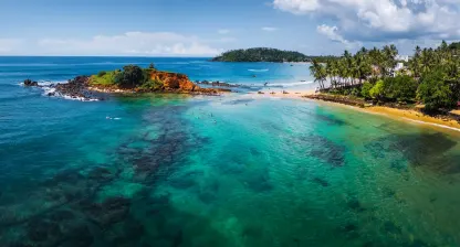
Parrot Rock (Mirissa)
A large flat-topped rock at the eastern end of Mirissa Bay, reachable by a short swim at low tide, popular for cliff jumping into 5m water below.

Coconut Tree Hill (Mirissa)
A small rocky headland east of Mirissa beach planted with tall coconut palms, offering a 270-degree ocean panorama 20m above the water — one of Sri Lanka's most photographed viewpoints.

Mirissa Beach
A 1km crescent bay 150km south of Colombo, Sri Lanka's primary departure point for blue whale watching (November to April), with a calm swimming beach and a growing restaurant scene.
Aktivitäten
- Mirissa Whale and Dolphin Watching Boat Tour4h
Mirissa, in Ihrem Tempo
Eine Walbeobachtungstour, am besten von November bis April, wenn Blau- und Pottwale vor der Küste auftauchen, oder ein Gang bei Sonnenuntergang auf den Coconut Tree Hill mit seinen schrägen Palmen.
Bentota
Bentota, ein Fluss- und Strandort an der Westküste, ist der letzte Halt (etwa 1 Stunde 30 Minuten auf der Küstenstraße). Zwei Nächte.
Mirissa → Bentota92,3 km · 2,5–4 Std. · A2vorbei an Weligama (Surfbucht), Unawatuna (Strandbucht), Galle (Fort von Galle), Hikkaduwa (Riffstrand)Rund um Bentota: das gesamte Angebot, Sie wählen aus
Die Einträge in diesem Bereich sind bisher auf Englisch.
Aktivitäten
- Bentota Beach Water Sports (Jet Ski, Banana Boat, Water Skiing)2h
- Madu Ganga Mangrove Boat Safari (Balapitiya)2h
Bentota, in Ihrem Tempo
Der ganze Tag in Bentota gehört Ihnen: eine Bootssafari auf dem von Mangroven gesäumten Bentota-Fluss, ein Halt an der Schildkrötenstation oder ein Nachmittag im Spa.
Rückflug
Der Transfer zum Flughafen dauert etwa 2 Stunden 15 Minuten, zum Rückflug.
Bentota → Airport113 km · 2–3 Std. · E01, E03

Erst vergleichen? Beginnen Sie mit unserer Hauptroute Sri-Lanka-Rundreise über 14 Tage, die jede Route über 14 Tage vergleicht, die wir anbieten.
Jeden Tag dieser Route fahren Sie mit eigenem Fahrer und Wagen; so funktioniert die Rundreise mit privatem Fahrer. Prüfen Sie die Einreisebestimmungen und die beste Reisezeit, bevor Sie Termine festlegen.
Machen Sie diese Route zu Ihrer
Diese Route ist ein Ausgangspunkt, kein festes Produkt. Öffnen Sie sie im Reiseplaner und bauen Sie sie selbst um, oder schicken Sie sie unserem Team in Kandy und bekommen Sie eine angepasste Fassung mit Angebot. Gezahlt wird erst, wenn der endgültige Plan steht.
Unser Team antwortet auf Englisch (WhatsApp oder E-Mail).